Broadway Planning Program Comes Into Focus

The City of Vancouver will next week present a policy report to the Standing Committee on Policy and Strategic Priorities that outlines the forthcoming Broadway Planning Program.
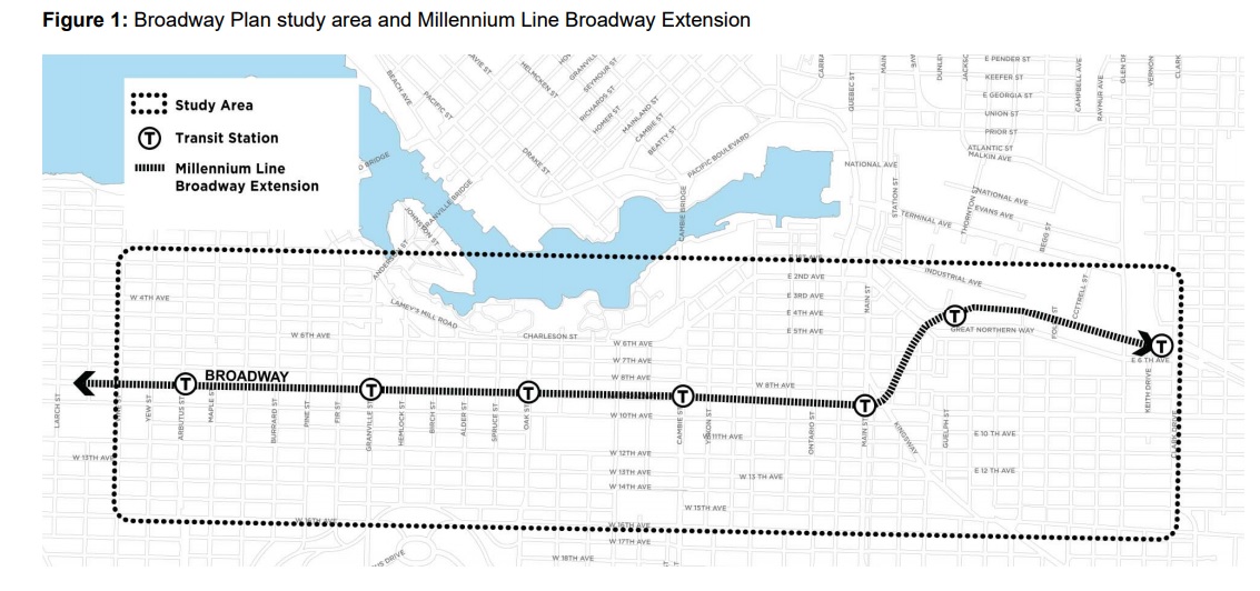
The planning initiative seeks to develop a comprehensive land use policy plan for the Broadway area in conjunction with the anticipated Broadway subway extension to Arbutus Street. The overall Broadway Plan study area, shown in an outline below, includes lands from Clark Drive in the east to Vine Street (two blocks west of Arbutus Street) in the west. The north and south boundaries (16th Avenue) boundaries of the overall study area were determined by considering areas up to 800 metres from existing and future stations.
From the report: “The plan will focus on opportunities to integrate development with the future transit along and around the Millennium Line Broadway Extension (Broadway Extension) to support the City’s goals of creating housing affordability, job space, social and cultural amenities, environmental sustainability and livability. Council is asked to adopt an interim rezoning policy that will apply while the planning program is underway and to approve an associated planning program budget.”
Timeline
The plan is expected to be finalized by December 2020, with the following anticipated 5 phases:
Initial – Background Phase (expected completion December 2018) comprehensive range of studies, including an area demographic profile, archaeological assessment, baseline utility capacity review, rate of change impact assessment, statement of significance/heritage assessment, transportation modelling, parking data collection and review, Broadway Extension project planning as well as other studies to inform the planning program work.
Five phases:
- Guiding Principles (expected completion June 2019)
- planning principles (coordinated with and informed by broader City Core 2050 guiding principles).
- Emerging Directions (expected completion December 2019)
- growth scenarios and patterns for change in land uses, housing, jobs, parks and public spaces, transportation connections and amenities (coordinated with and informed by broader City Core 2050/Economy Lands Studies, and Broadway Extension project design)
- Refining Directions (expected completion – June 2020)
- draft policy plan for land use, density, layout, built form, and design. This will
integrate policies to increase social and rental housing, while retaining existing rental and increasing protection for tenants. - draft public amenity strategy addressing housing, community amenities,
transportation connections, infrastructure, parks, public space, public realm
improvements, and social and cultural amenities.
- draft policy plan for land use, density, layout, built form, and design. This will
- Finalizing the Plan (expected completion – December 2020)
- final policy plan, including enhanced renter protection policy in the Rental
Housing Stock ODP areas included in the study area. - final public amenity strategy.
- final policy plan, including enhanced renter protection policy in the Rental
- Implementation (to be determined)
- rescinding Interim Rezoning Policy
- referral of by-law amendments and subsequent policy amendments (e.g. to
Community Plans)
Area of Study
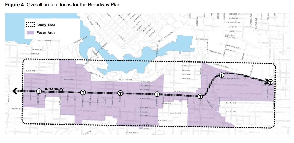
Within the overall study area there is a focus area to be reviewed for potential land use
change as shown on the map below, shaded in purple. Generally, this includes the C-3A, C-2, RM-3/4, FM zoned areas, and parts of the Burrard Slopes mixed employment area within proximity to the station areas, as well as VGH and City Hall Campus. It excludes RS and RT zones, the False Creek South and the Southeast False Creek ODP areas, the majority of the Mount Pleasant industrial zones and False Creek Flats industrial and mixed employment zones. The RS and RT zones will be addressed through the ‘Making Room: Adding Housing Choice in Neighbourhoods Across Vancouver’ Planning Program, a key action item coming from the Housing Vancouver Strategy that is also going before council next week (click link above for details).
Policy Considerations
The City also notes a number of other policy consideration that will shape future development scenarios. These include:
- The Rental Housing Stock Official Development Plan – City will explore renewal and retention of existing rental apartment stock. The rental districts within the study area make up one of the City’s core rental areas, containing 17,680 units of existing non-market and market rental housing – including 27% of the City’s total purpose-built rental units in areas covered by the Rental Housing Stock ODP. Planning work will explore potential future options for these sites, noting that rental replacement and enhanced tenant protection and relocation will be prioritized.
- Jobs and Economy Policies – the Metro Core Jobs Plan is being updated by the Employment Lands and Economy Review Study set for 2019. In conjunction with that study, the Broadway Planning will consider protection of lands for job space and provision of new commercial density. Existing industrial zones will be largely excluded, save for a small stretch on 8th Avenue.
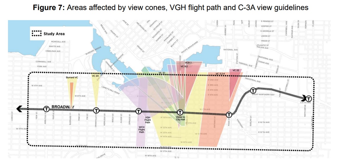
- Heights, Views & Other Considerations –
- Queen Elizabeth View Corridor (View #3) – testing will occur to explore whether select buildings along Broadway could enter into view 3.1 without
eroding the overall view of the city within nature - Vancouver General Hospital Flight Path – VGH has a helicopter pad for emergency transport to and from the hospital. The VGH flight path is a wide apron that swings out to the north of the VGH heliport. Transport Canada limits building heights along Broadway – quite considerably between Oak
and Laurel Streets.The City and VGH have agreed that proposals
for new towers will be brought forward for review and discussion with VGH, Transport Canada and the helicopter operators. - C-3A Guidelines (Views to City Hall) The Cambie Street (east side) C-3A Guidelines and Central Broadway C-3A Urban Design Guidelines which restrict heights along Broadway between Laurel Street and Yukon Street in order to preserve views to City Hall from public points along the north
side of the False Creek seawall will be reviewed.
- Community Plans – The Broadway Plan study area includes lands covered by three Community Plans: Mount Pleasant Community Plan (2010), Kitsilano Neighbourhood Plan (1977), and Fairview (1974) – these will be reviewed as part of the process.
- Vancouver General Hospital (VGH) and City Hall Campus – As both City Hall and VGH will be undertaking master planning initiatives to plan for their future in the near term, the larger context of these two major employment
campuses and the area’s role as an important gateway to the City Core will be considered through Broadway planning.
- Queen Elizabeth View Corridor (View #3) – testing will occur to explore whether select buildings along Broadway could enter into view 3.1 without
Other Interim Measures
Interim Rezoning Policy During Broadway Planning Process
The City will seek to limit rezoning applications being made until the plan is finalized. It appears that new rezoning applications will only be considered for public or non-profit institutional, cultural, or recreational uses, non-market housing, or heritage retention.
New Policy Measure to Curb Speculation
As has been highlighted in recent media attention, the City will also put measures in place to prevent any land speculation over the planning phase under a new policy entitled: Development Contribution Expectations in Areas Undergoing Community Planning. This will include a new Development Contribution Expectation (“DCE”) that will charge a pre-determined rate based on existing zoning and independent consultants’ review of the economic viability of proposed projects factoring in the prioritization of job space and affordable housing.
From the report: “The overarching objective of the DCE policy is to curb land value speculation in the market. This objective is best achieved by providing buyers and sellers with clear and consistent information about the City’s priorities and objectives for the Broadway Planning program. With the information, buyers and sellers will be able to properly account for the City’s expectations when identifying a fair price for land on the Corridor.”
The report further notes that achieving additional density above existing zoning for strata will be limited.
The Broadway Planning Program policy report goes to Standing Committee on Policy and Strategic Priorities next week. A full version of the report can be viewed here: http://council.vancouver.ca/20180620/pspc20180620ag.htm


